
Geoscience and Offshore Wind JIP
Project Overview
Title: Developing 3D ground modelling workflows using publically available subsurface datasets
Timeline: October 2024 - September 2028
This project is part of the Geoscience and Offshore Wind Joint Industry Programme, and a partnership between RWE, SSE Renewables, Vattenfall, and Geosolutions Leeds.
It seeks to blend geological and geotechnical approaches to develop 3D ground models that enable cost-effective, safe turbine foundation and cable route design (Fig. 1).
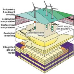
Figure 1: Recommended integrated three-dimensional ground models that capture sediment mobility, and integrate geophysical, geological (including geomorphological) and geotechnical information. From Velenturf et al. (2021).
The adoption of three-dimensional geological models as a standard approach is particularly important in many prospective development areas, such as the North Sea and Irish Sea, where the subsurface stratigraphy has been shown to be highly heterogeneous, undermining the cost-effective placement of monopoles.
A scenario-based approach will be undertaken, using different grid designs and monopile depths that span a range of substrate intersections. Grid resolution is a particularly important consideration as future developments in offshore wind are focused on very large turbines.
The workflow will accommodate future innovations in ground model development, such as dynamic bathymetry and sediment mobility layers, to account for the substrate architecture and erodibility in relation to seabed hydrodynamics. Improved modelling of sediment suspension and scour would assist in modelling habitat creation and modification provided by complex surface features to increase seabed biodiversity.
To minimise issues related to data confidentiality and the sharing of outcomes, we will use publicly available data. Prospective areas include offshore Netherlands and the Irish Sea. Any dataset that is well documented will also yield new insights into palaeoenvironmental change in the North Sea during the Quaternary. The main deliverable will be workflows for integrating geotechnical and geological datasets into 3D geological models.
Progress
The project team and JIP partners met on the Isle of Man in June 2025 for the first steering group meeting. The meeting also included a field workshop, during which outcrops of Quaternary ice-marginal successions were visited. The impressive outcrops are an ideal setting for the team and partners to share knowledge on the heterogeneity and geotechnical properties of these successions, which are analogous to those encountered in the subsurface.
Understanding the sector's business challenges enabled the team to refine project goals. A key outcome of the workshop is that there is a need to train industry geoscientists and engineers in the architecture of Quaternary successions, and to use outcrop analogues more generally to reduce uncertainties during all stages of windfarm developments, such that the interactions with the seabed and substrate are kept to a minimum, and that offshore wind remains an environmentally sustainable renewable energy source.